The main purpose of the Selection Acts of
the 1860s was closer land settlement. Through them squatters were forced to relinquish
some of their land,
and as a result his in-laws, the McHaffies, had their grazing run over Phillip Island
1842-68 reduced to 640 acres though this was well before his niece Elle Blanche Lousada
1883-1966 #274 married David McHaffie 1864-1940 #346 in 1903. But the
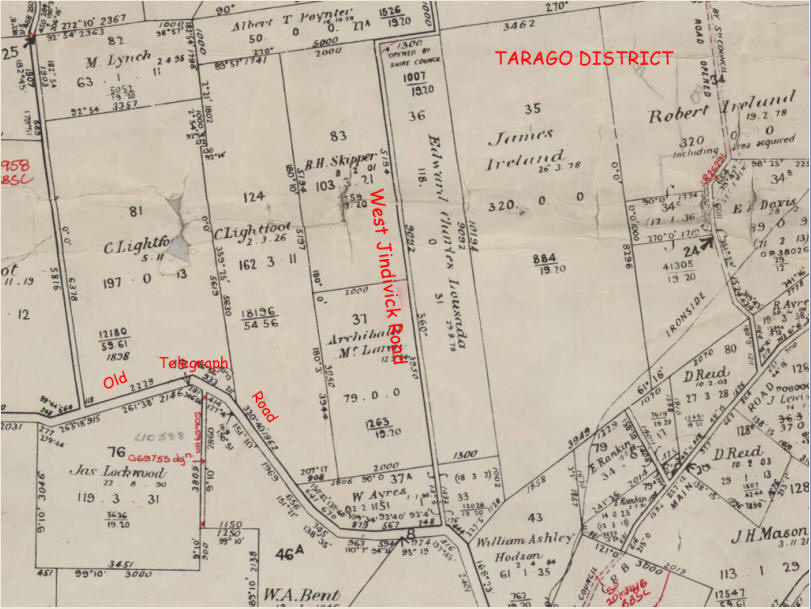
Warragul land selected by Edward Charles Lousada was uncleared, and probably not subject to an earlier grazing
lease. Some current-day scenes in the area may be found
here.
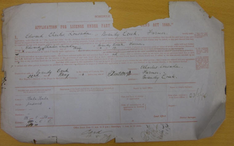
Edward Charles Lousada
was young at the time. He arrived
in Australia in
late 1871 or early 1872, and stayed
for a while with his brothers
at Hastings. One of his brothers was Howel
Arthur, father of Elle Blanche. At this time, so
ref 124 p8 tells us,
the nearby Brandy Creek region was opened up in a rush of enthusiasm,
no doubt due to its reported rich soil
and good rainfall.
Enquiries came from as far away as Salt Lake City with Brigham Young (a
leader of the Mormons) wanting land for his 187 children to settle! Edward Charles selected
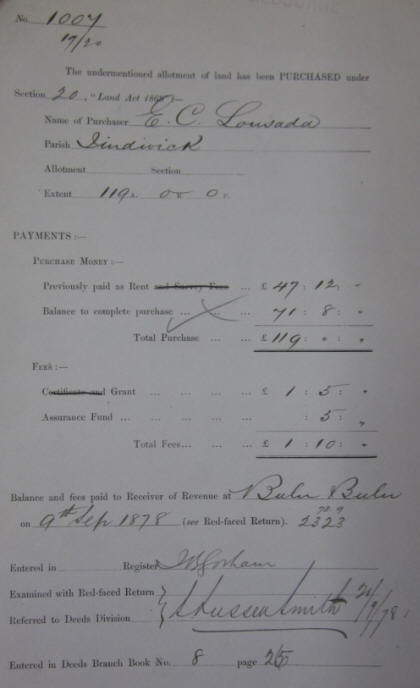
a little over 118 acres but paid for 119. Later, Edward Charles Lousada put up
for auction
on 30 Jun 1893 through his firm
William Hamilton & Co a small (17a 3r 2p) parcel of
land which aside from a probable typographical was the same size as the (18a 3r
2p) piece abutting the south end of his block shown above in the name of W
Ayres. We infer that Edward Charles Lousada had earlier bought the parcel from W
Ayres but that he was forced to sell - the auction notice stated the sale
was by order of the mortgagee.
Blanche Henrietta Skipper was a
Barrow cousin of Edward Charles Lousada and leased
land across West Jindivick Road
(see map above left) on 18 Jan 1879 and finally bought it on 8
Feb 1901 (data from Victorian Public Records
Office land records file 7759/19).
However from
ref 124 we learn that
Herbert de Symons Skipper - a Barrow cousin - bought Edward
Charles Lousada's block and Albert Poynter's selection after selecting elsewhere unsuccessfully (pages 43 and
47). As the historical notes
indicate, Edward Charles left his block to Blanche when he left the district;
so Herbert who died in 1901 must have been acting for his sister in these land transfers as well as in
the case of her original block (as we observed in examining
the original records). The
grave of Herbert de
Symons Skipper, his wife Ellen Caroline Rutherford, and his sister Blanche
Henrietta Skipper are at the nearly Drouin West Cemetery on Old Sale Road. Blanche Skipper's death gave rise
to some
correspondence with General Sir George de Symons Barrow
who was aware of his Australian Barrow and Lousada
cousins.